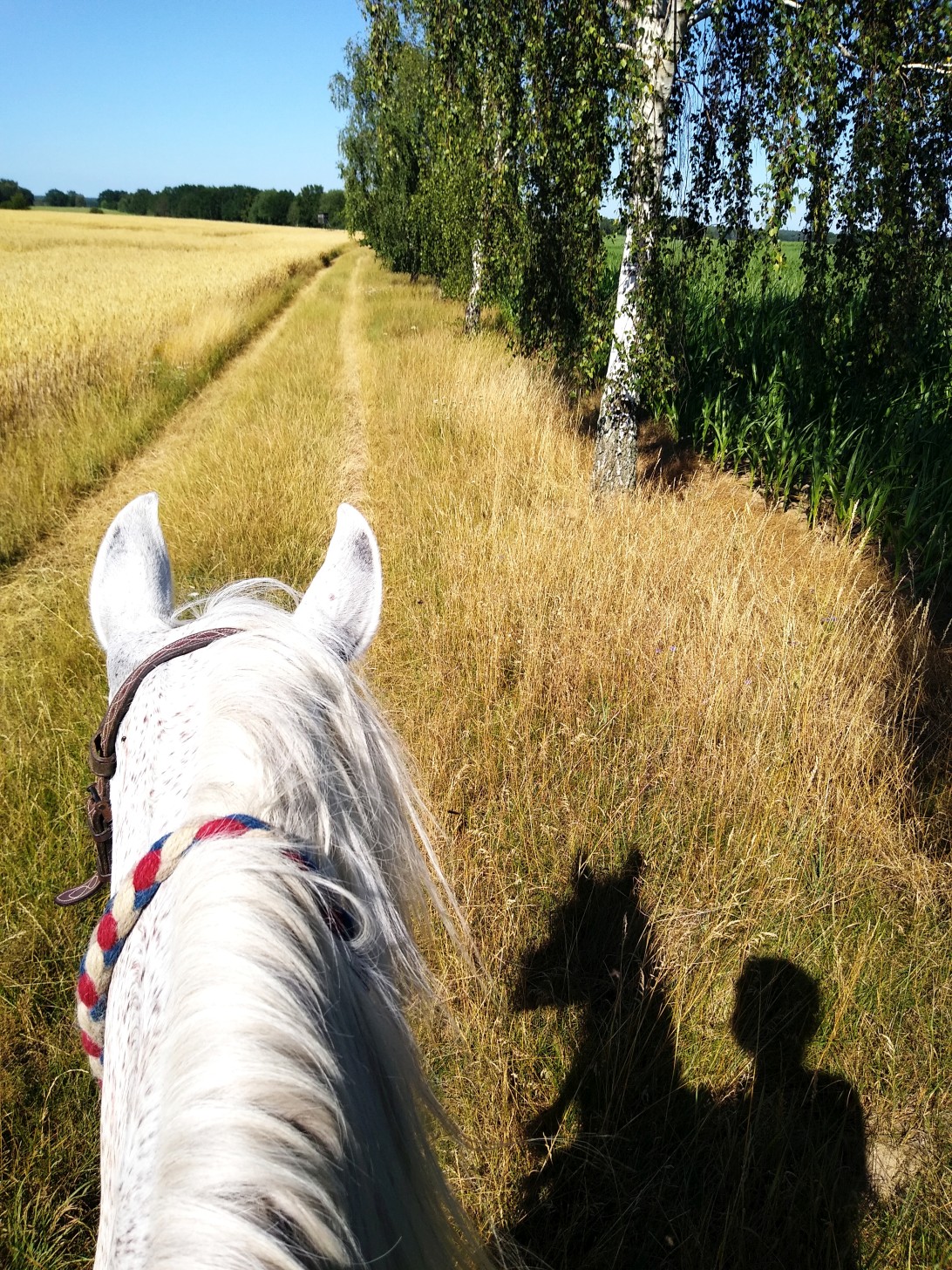
 TAUNUSREITER
(c) Frank Mechelhoff 2019 - All rights reserved
contact: taunusreiter
(update August 2020)
TAUNUSREITER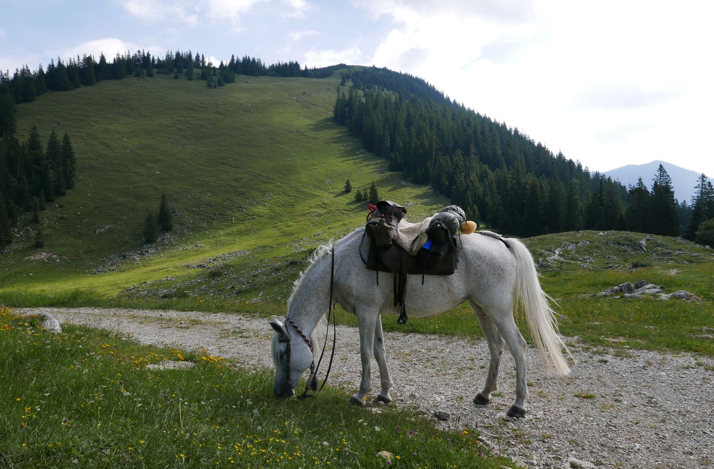
Some consider Arab horses not particularly
suitable for trail rides because they are too sensitive and
nervous, and too lightly built to carry adults and luggage.
I don't think that can be generalized. Certainly there are
Arabs who are quite “strenuous” and difficult to ride, as
well as weak ones and poorly built ones, which one cannot
manage even with a lot of educational effort. Today's
breeders often select according to the wrong criteria, and
many breeders don't understand anything about riding. The
results are often breeding products with exaggerated
expressions, extreme heads that often do not even reveal
whether they are a mare or a stallion, and jumping gaits
that nobody could or would ride.
I bought Khorsheet 8 years ago as a well-built,
compact, universal riding horse and have ridden 20,000 km
with her since then; During the entire time she needed the
vet 3 times, except for vaccinations and dental checks. She
is extremely pleasant and comfortable to ride. On endurance
rides she is constant and always has great values, but she
is never the fastest (or I don't like it that fast).
Just as she has kept the humor and glamor of the
young horse, she is also calm, professional and clever as
soon as the terrain becomes difficult. Always in the best
posture and with a pleasant rhythm. I don't remember having
to teach her that. Only riding with a bit didn't work at all
for several months. But she was then ready for curb bit
incredibly quickly. Our
daughter rode her like since she was 8 years old. With the cavalry of Prussia
she would have been a General's horse. If I 'll still alive and
ride at age of 80, I only ride a horse like her.
I have a younger Egyptian bred mare as well,
planned as my junior horse. For a while I planned about
riding both alternately. But I decided against it: the
7-year-old is still too unridden and not calm enough. Where
Khorsheet is slowly carrying the weight with her
hindquarters, Muyah desperately pushes it forward. Adding
her would quadruple the risk, but hardly increase potential
performance. Because changing the hand and riding horse
every 3-4 hours creates a maximum of a fifth more distance
in my experience, and then you have sweaty saddlepads. I
therefore decide that my best and most reliable horse need
to carry me alone. She's never let me down in eight years,
and I trust she won't this time either. When Khorsheet gets
tired, which happens rarely, I notice. Muyah keeps walking
until she gets too tired and therefore would probably need
twice the amount of rest and food. But Khorsheet is still
the better eater, has never left anything, and never had
colic.
Two weeks before the ride, Khorsheet weighed 425
kg (measured after a 57 km raid). Until the ride she got some
extra feed to add, I would have preferred her at 450 kg. I myself weighed 86 kg (81
kg after the ride), Khorsheet may also have lost a
bit, but only a little. This is almost inevitable on long rides. Luggage weighed 22 kg
(without food), military saddle 9.5 kg, Woilach 2.5 kg. Link: equipment
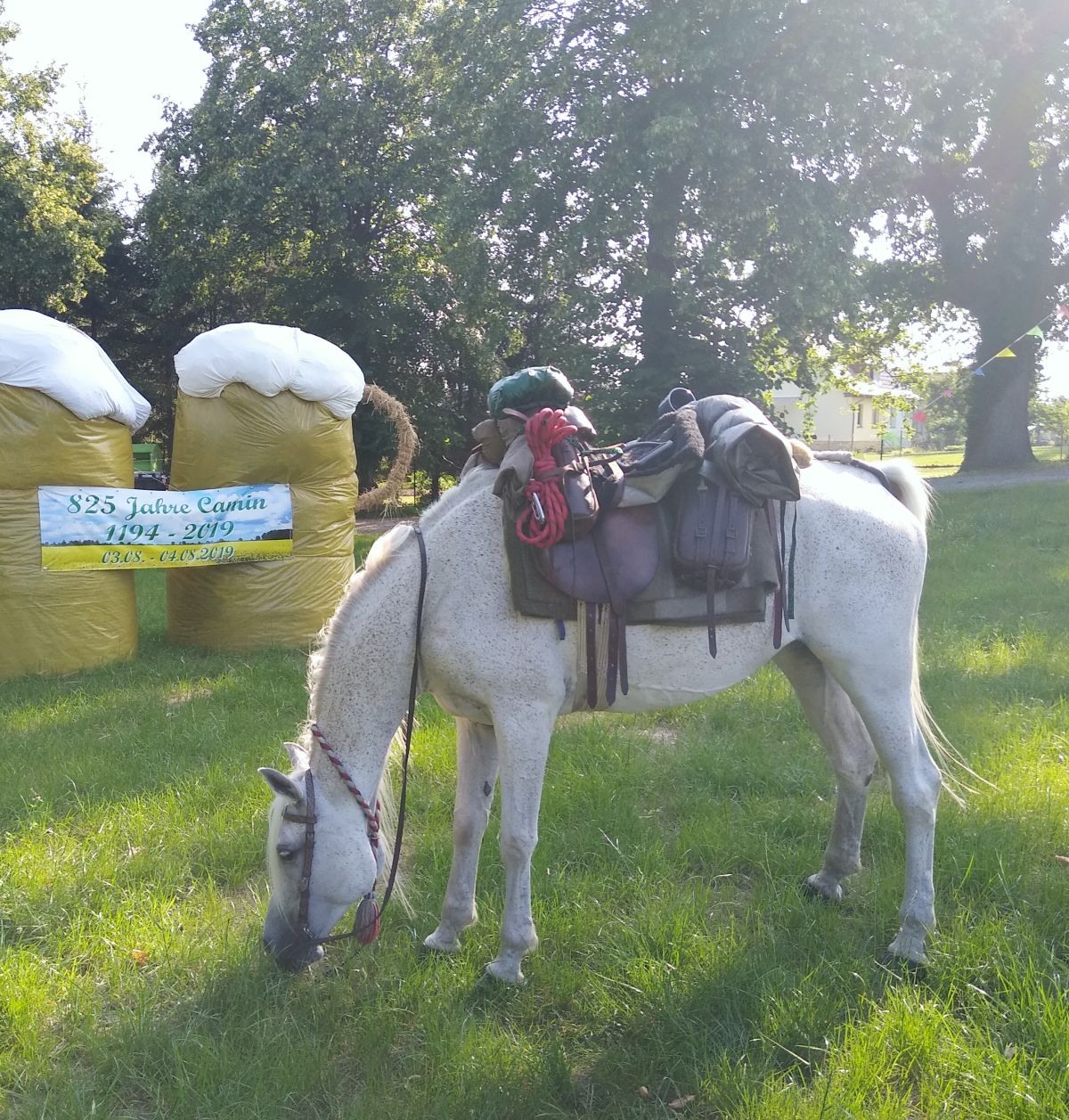
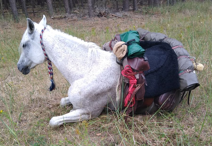
Photo: Khorsheet on the 24th
day of riding - the Redefin oats packed on top - 90 km to the
sea
On the long way it is hardly possible to feed as
much as the horse consumes. On 20 of the 27 riding days I
had organized grain in the evenings in the overnight
quarters or during the day on the way. 7 of the 27 days I
either had no concentrate or had to make do with the reserve
of the previous day. The approach “ 1 kg of oats per riding
hour“ (or other
grain) corresponding to about 11.5 MJ of energy seems to me
a good rule of thumb. My mare could eat 6-7 kg of good oats
per day, a little more with high loads and excellent oat
quality. In many cases, however, this was not available, and
we had to make do with whatever was available, like
squeezed oats, other grain, or low-energy muesli. In areas
without a lot of cereal cultivation and hardly any horses, I
always bought oatmeal when I went buying food, and fed some
of it straight away (only the good branded flakes, which are
less floury and have more "bite", horses don't like the
others). Whenever I got whole oats somewhere, I always took
a break to feed 1.5-2 kg.Then I took a full sack with me and
fed 4-4.5 kg of it in the evening and the next morning,
depending on the quality of the pasture at the overnight
place. With good pasture, I was able to keep some reserve
for the next riding day so that I didn't have to organize
concentrated feed every day. Then the feed of around 2 kg
for the evening and morning was already scarce, and good
grass was even more important. I attached great importance
to this when choosing where to stay overnight (and you don't
always get that when you're out and about in dry summers).
Horses that march for days not only need additional feed,
but also better grass than locals who mostly stand around.
Not everyone understands that. Therefore I cannot agree with
those who claim that the most important thing for the hiker
is enough good grass. It is important, but it isn't all. In
northern Germany I had Khorsheet alternately in pit stalls
and on private and garden properties with fat clover grass.
On the dried up pastures she would kept hungry. But I know
horses very well that cannot tolerate such grass at all.
Energy-saving ridestyle was important as well. I
seldom rode at a walk for long instead of leading it at the
reins. A well-conditioned pure- or half-blooded horse
consumes the same amount of energy per km when walking or at
a steady trot on the flat and does not work up a sweat,
often even less when trotting and is less bothered by
insects. At a trot it is also sooner finished with the daily
output and then has more time to eat and rest! Of course,
the luggage must then be strapped so tightly that it does
not bother horse or rider. The same applies to ponies that
are not too heavy; 25 years ago I rode with my Iceland pony
- after initial training for endurance rides - the same
daily performances as today with the Arabs and also trotted
a lot. And after I walked frequently for 10 hours at first,
what really gets to the kidneys, I say today "7 hours is
enough" (as a daily average pure riding time on a ride
longer than 3-4 days). You can take a lot of breaks, but
only where there is good food for the horses. For beginners,
and those who have to learn to organize their luggage so
that it does not get in the way of higher gaits, five hours
are enough.
After riding 1,092 km in 27 days, the choice and
methodology were confirmed. The initially somewhat
sporty stages (42-43 km daily average) calmed down and
shortened (from 7:05 hours of riding time average per day to
5:45 hours). This
is probably the method to ride even longer rides (1,000
miles and more). I never favorized rest days when the organism is
set up for constant movement and high feed intake. Instead I prefer to keep
moving and ride a little shorter if there is excellent
accommodation, or weather is extremely bad.
The idea for the ride developed in 2016, reading about Endurance ride
"Hamburg-Munich" (1976) in the rare-to-find book
of that participant Ursula Schmitt . These riders had to go west around the Harz, through the Salzgitter area, and
many complaints were about hard roads and lots of asphalt.
You could not ride further east back then due to the barbed
wire border with the DDR. It should be much more pleasant
today some more miles more eastwards, I thought to myself.
At first, my idea was to make the route like an endurance ride to be worked out, with best footing and daily
distances of 60 to a maximum of 70 KM. On the Alb-Ritt
I experienced that my mare can do this for several days
(without luggage) and stay in great shape or even gain
weight. Ridden at tempo 6 (minutes per km) - the better
paths at a light trot, the worse ones leading at the walk.
6-7 hours of riding time a day so there is enough time to
eat and rest left. I think almost
every good horse can achieve that. Not too heavy,
healthy, trained, slim, fit rider, etc ... provided.
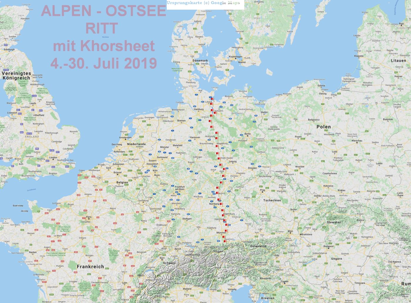
Instead of north to south, I wanted to ride south to north. And then the idea: Instead of going to the heath south of Hamburg, the route wouldn't be much longer when to cross the river Elbe, ride along the Schaalsee, to the Baltic Sea (Luebeck Bay) ... " From the Alps down to the sea ” .
I divided
the route
into 16 daily
stages and measured
the initial planning exactly with 988.6 km.
On the other hand, I still like the idea of
riding the route in 16 days. I think what my horse did with luggage in 26 days - the trip to
Redefin was an extra day - many good horses (beside my own) could do this in 16
days without luggage. But a significant lower
number in 12 or 14 days.
From the foot of the Alps down to the sea, once
across, or rather lengthways through Germany, away from the major traffic
axes, through sparsely populated areas and large forest
areas. That
was the master plan.
But how do you plan something like this in detail ? This is where the wheat is separated
from the chaff. Trail riding quarters? You can look for how
many hundred kilometers they are completely missing. Very
simple-minded people take Google or a routing program and
start walking as the crow flies (in the past used to take a
map, ruler and pencil). You will come across so many
obstacles on the way that you don't need 16 days, not even
27, but at least 47. Afterwards you will have a lot to tell
that amuses your audience, but was not very amusing in
direct experience. And whether the horses benefited from it
is another matter entirely ...
The idea with the school atlas map is not entirely
wrong, at least to start with. The next thing you have to
do is look at the river valleys. In urban, industrial and
commercial areas, large wind and solar parks, large military
training areas (if still in operation, you can secretly get
through the others in this country), traffic junctions: all
of this has to be arched. You then have to zoom in
more and more. Often you plan a part of 30 miles and then
realize: No, it won't be a nice route. 20 miles west or east and
it might run smoother. And start again.
After 27 days of riding I
say: I came through a
sparsely populated Germany in a way that I never
believed, that something so beautiful still exists - full of undisturbed
nature, almost without large roads. I only saw larger
settlements when I rode into them - every four days - to
buy foodstuff. The mountains of southern Germany, endless
forests, the Danube, fifteen feet high riding on dams in a
fresh wind. I relived a northern Germany as I knew it from
my childhood 50 years ago, in a tin-shell child bike seat,
behind the handlebars in front of my grandfather, driving
over sand paths, through the Venn, singing songs
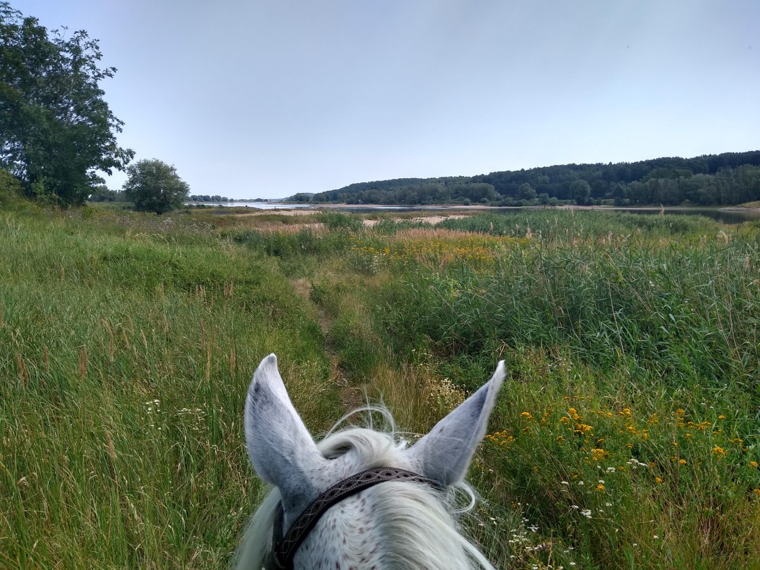
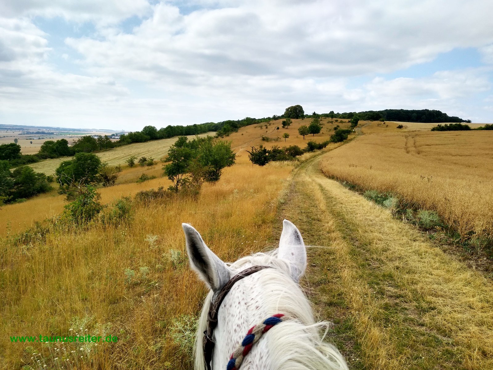
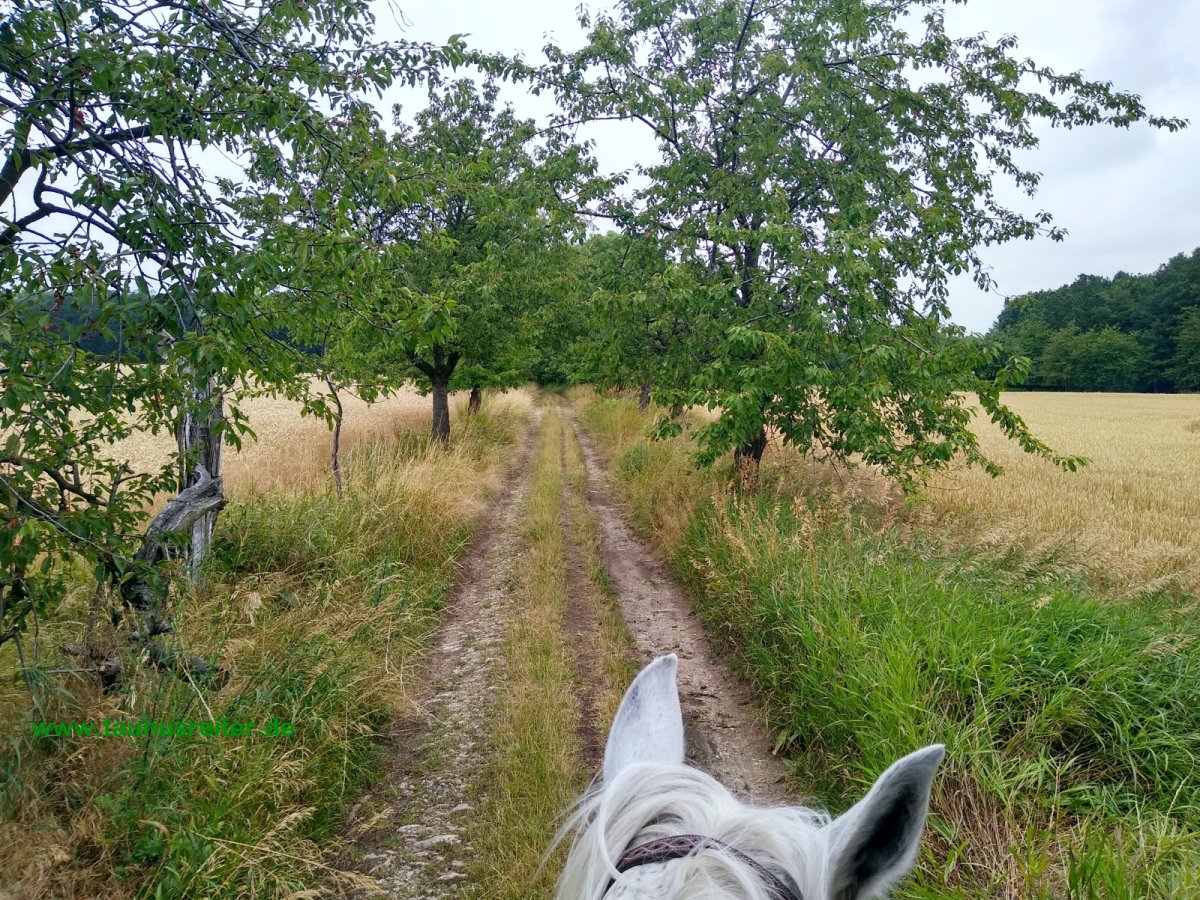
together. This time there were the pricked ears of the
beloved horse in front of me, in the canter over solid,
endless sandy paths. Pine forests, endless fields,
avenues, and above the blue sky with bushy white clouds.
Nothing bothered. It was perfect.
The longest section of the route was in Bavaria,
then two days through Thuringia, 4-5 days through
Saxony-Anhalt, just under a day in Lower Saxony, and 3 days
in Mecklenburg-Pomerania.
We sidestepped the Munich area through the
Ebersberger Forest. The area around Kulmbach, as well as the
crinkled heights of the Franconian Jura, Franconian Forest,
as far as they do not follow our riding direction from south
to north. Main, Wilde Rodach and Rennsteig indicate the
point where the German main watershed (710 m above sea
level) is the easiest to climb. The Autobahn 9 occupies the
geographically favorable main altitude, and leaded me to
ride four days west of it, always out of hearing and sight,
varied over small hills with a constant change of field and
forest, crossing the Saxon Saale twice, to the Hermsdorfer
Kreuz, where I got very close to her.
The Thuringian flat agrarian field was also to be
avoided, namely via Dorndorf, Camburg and Eckartsberga. The
firm feel of a gate between northern and southern Germany.
Sharply along the eastern foothills of the Harz Mountains -
Quedlinburg remains to the west - and down to the
Magdeburger Börde. From here the route is flat until to the
small dune hills of the Altmark. Over them, and through the
forest area of the Göhrde, it goes to the Elbe, and along
the Schaalsee to the Baltic Sea.
Since you have to split up large tasks until they
become small and manageable, I created several routes that I
worked on. In the end I made four quarters of about 250 KM
each: Degernpoint, Abusinia, Holzberg, Plothen, Memleben,
Großgermersleben, Solpke, Hohenzethen - names like
lighthouses, in the end you almost believe that you can now
ride without a map because you have everything in your head.
I took a few small modifications and alternatives with me
and wanted to make spontaneous decisions when it was the
time to decide. At some point I realize that the Redefin
State Stud is close to the route (one extra day). That you
can't get further in a north-westerly direction from there,
because there are two military training areas and the
Bundesbahn has dismantled all old level crossings over the
Hamburg - Berlin rapid train railway, which only the latest
maps show, made extra effort and should only be mentioned
here as an example. Another classic was, one ferry (across
Danubia river) was closed between initial planning and
start.
I planned the route on the PC, with the tour
webportal gpsies (discontinued in January 2020),
Openstreetmap maps and Google satellite images on the one
hand, as well as with the MOBAC program, and topographic
maps from around 2009 and the official, freely available and
current topographic maps of Bavaria and Thuringia on the
other hand. From MOBAC I also cut the
maps for my navigation app LOCUS and formatted them (as
sqlite-db) . About 2 GB of memory, the
raster maps are not bigger. A replacement SD card is of
course also included.
For the first time, I want to ride a ride longer
than five days with a GPS smartphone instead of
paper maps: 1000 km of planned route in topographical maps,
that would make a terrible pile of papers. But of course I
want to have my usual maps (Topo Map 1:25,000) virtually
with me, so no Garmin GPS, but smartphone (raster maps). The
problem with their battery performance in GPS operation. My
previous devices only managed 5-6 hours with GPS, my used 8
“tablet (actually predestined for it) even less now. A few
weeks before the ride, I buy an extra powerful new cell
phone, a Motorola G7 Power with a 5 Ah battery. It's a bit
bigger than my older ones and lasts 1.5-2 riding days on one
battery charge. To recharge on the go, I tried to use a 28 W
solar charger and a power pack - plus most importantly a
quick charger for the socket. It turns out that sockets are
absolutely necessary every 2-3 days. For safety - and after
corresponding disappointments on the 3-day trial ride - I took all
the riding stages with me (with the exception of the detour
to Redefin), printed out in multiple columns as a pdf: 18
double-sided pages of paper-like waterproof polyester film
(120 µm). But
with very little extra for errors and rescheduling. After this "backup" I ride
for two full days because lack of electricity and the power
pack gives up the ghost. After the ride, the mobile
phone's quick charge function ceased works. I send it in and get it
back unrepaired: Allegedly it has water damage - it was on
once during a thunderstorm ... (Smartphone is still in use
18 months later)
25 days (Redefin extra, instead of No. 22, plus 1
day), 999.3 km
Start Münchner Hütte (Spitzingsee)
1.
Maxlmühle, Mangfalltal (38))
2.
Rasthaus B 12 (47)
3.
Thenner Weiher (39)
4.
Niederhinzinger winter paradise (39.5)
5.
Abusina Eining Roman fort (38)
6.
Holzberg Tiefenhüll (38)
7.
Trautmannshofen (41.5)
8.
Siglitzberg (38)
9.
Plankenfels (45)
10.
Oberdornlach (40)
11.
Langenbach, Sweden Guard (40)
12.
Plothen-Stockert (44)
13.
Serba (41)
14.
Eckartsberga, Holländermühle (34)
15.
Allstedt special airfield (40)
16.
Valley Meadows One, Golden Bridge (37)
17.
Kroppenstedt (44)
18.
Kuhlager Bebertal (40)
19.
Solpke (38.5)
20.
Hohenböddenstedt (44)
21.
Hohenzethen (43)
22.
Brahlstorf (45)
23.
Knese, Dutzow, Gutshof ruin (43)
24.
Dassow (34)
25.
Redewisch sea car park, Klützer Winkel (27)
download as .gpx
Among my four or five German M25 military saddles
I look for the softest pads and attach them to Khorsheets
saddle (size 2) a week before the ride. It's not her everyday saddle because it easily rubs off
the hair on the heels of my short-backed horses. To prevent
this as much as possible, I put a reindeer skin underneath.
This is a little difficult to dry out on the way, but in
summer it is actually possible if weather is dry. It's a bit
older (the reindeer skins last at best for a year of regular
riding).
After looking through my Woilach, shortly before
the ride, I buy a "new" one online, type Bundeswehr,
slightly larger than my last, well-used Swiss Woilach, and
the condition of the material is still excellent, despite
the patch from 1964 (i.e. older than me).
As saddlebags, I unfasten the not-so-large panniers at the back like before , and the lighter Hussar front panniers that were auctioned on ebay a few years
ago are supposed to have their first continuous use.
To attach them to the army saddle 25 I did some leather
working to fix packing straps so that they sit tight without
wobbling. 3 weeks ago they had passed their first practical
test on Muyah (three-day ride in the Rheingauaunus) without
attracting negative attention.
I think for a long time whether I should take a
breastplate with me, but decide against it, because
Khorsheet is in the best condition, has a good belly, no
saddle slips back and I don't want to ride her thin. It is more likely to slide
forward. The
tail strap therefore seems more
important to me, since it
only goes uphill for about 3 hours on the first day, where I
plan to lead, but then it tends to go downhill for 4 weeks -
and saddles sliding on the shoulders are very uncomfortable,
especially with luggage, and cause chafing behind the elbows
(belt position). I take our Biothane tail strap (with a small faux
fur protector for the hip hump). Because I always oil the
tail beet a little on the way and carefully make sure that
it is the right length, there are no problems with it.
Unlike on previous long rides I take this year no
high rope, but the first time a trail riding paddock with foldable bars. Although she stands quite
well with the rope and does not tend to panic, when she is
free she runs around more, and my fear is that she is
standing around too much out of worry about stepping on the
rope and don't eat well. I just feel like she doesn't like
the rope. She is a very hungry pony in general, but as with
all Arabs, minor ailments cause her to stop eating, and that
would be extremely unfavorable on such a long ride.
Especially for this ride I
ordered a lighter and smaller mobile fence energizer (my
third in 30 years) than we normally use on our trips, a
Patura P10, which has also proven itself well and only needs
2 mono cell batteries. I have 7 dismountable rods with me, and only want
to stretch 1 band (10 mm), almost 80 meters, because this is
sufficient for her, without gate handles. Paddock equipment and
equipment take up a lot of space: one of the two front
panniers.
My old feed bag has many holes after 30 years of
service, and it was actually always too fat and too short. It will be replaced by a
new narrow one (von Zölzer, size SL).
I also leave away the halter in favor of
Khorsheets nice woolen neck strap. Halters underneath and
head pieces that are too thick are an imposition for horses
in hot summer and cause chafing on the face. Most of the
time I don't need to tie her up because Khorsheet never runs
away from where she has to eat, but devour every blade of
grass moving around in semicircles. If she ever gets
frightened by something that rarely happens, she jumps 3
meters and then stops and looks.
Just in case, a Fiskars saw
(30 cm).
Little things: titanium
spoon and fork instead of the usual Wehrmacht cutlery (saves
100 g). Otherwise
knife, compass, GPS smartphone, harmonica on the man. Hip bag with cash, 24 Ah
power bank, charging cables and a Lumix camera with Leica
zoom. However,
the pictures are not much better than the cell phone
pictures.
A folded 28 W solar charging module for the
smartphone fits under the "rider bag" ( all pure fantasy, these
details about charging power ).
Otherwise just the usual equipment that I had with me on all longer rides since 1996
and 1988. As
riding breeches I wore the Eurostar corduroy pants because
all my Pikeur were already too used. After 4 weeks it has held
up quite usable, but now you can also see the traces on it.
On the Saturday before start, I renew
Khorsheets' shoes. 1000 km planned route, plus some extra
ways - mainly to find places to stay overnight, buying oats
and foodstuff - I reckon a total of almost 1100 km.
Khorsheets normal shoes (St. Croix eventer) last about 1000
km. Of the 14 total sets (since 2012) she hasn't lost a
single one. So I don't have to “experiment” and can use our
“normal” fittings, with two side caps and videa pins in the
rear - almost completely sunk because I've come away from
them with her in recent years. But now they are usefull for
durability and safety (slow riding speed). My tools can
completely remain at home for weight reasons, except a
handfull of horseshoe nails. If in Northern Germany they
will be worn out, I have to look for a blacksmith and, if
necessary, give it a day. Research in advance on the
Internet does not yield any suitable addresses, except for
the blacksmith from the Redefin State Stud. - In the end,
they held up perfectly and could be used at home for two
weeks after the ride, a total of 1177 km. Only the toes were
very thin. As a precaution, I hadn't wanted to shorten her -
quite large - hooves as much as usual, and I hadn't pointed
toes either. If I had welded on some protection on the toe,
which is often recommended for very long rides, the fitting
might have been "nicer", but not so the horses joints
probably.
This shows two things: her easy way of going,
which is gentle on the shoes and joints, and the very good
footing on our route.
Because all of her
shoes held in place well with 4 nails I will do them
this way again. On the last day, however, I still get sleeves,
and on the morning of the start I add a 5th + 6th nail
in them, probably
unnecessary.
Breakfast with the young house master, I have to
force him some money. After all, they run a professional
horse business. He ordered pizza and spent beer last night.
The horse
shouldn't stand for free either, and I also take a daily
ration of oats with me. Unfortunately, I forget to pack the mosquito spray
(0.5l bottle) - sometimes it is difficult to keep everything
together in confusing stables.
Today we want to go from the Main across the main
top of the Franconian Forest; it's going to be a tough day.
First ascent towards Veitlahm; the paths are rather firm
with a few unmotivated riding bans, all only signposted in
one direction and without usable alternatives. First break
10: 40-55 on a meadow between Kirchleus and Unterdornlach, 8
km, lots of asphalt.
Finally better ways where you can trot. Historical
roads used to run over the wide ridge, there are two "high
roads" on my map. But we try to take a slightly shorter, but
calmer path that has one more ascent. We are approaching
Losau, main village below the ridge, the road layout and the
transition have been changed somewhat, making crossings more
difficult for riders. But at least there are no fences
around. At 12:15 I stop at the well, let the horse eat a few
straws, keep an eye out for an inn somewhere, but can't find
anything. The village is dead quiet except for a couple of
yapping dogs. Straight ahead, steep ascent to the Franconian
Forest, good soil for Khorsheet, I let myself be pulled by
the tail (tailing). Instead of the mixed forest in the valleys
further up, now mountain pine forest.
12: 50-13: 40 second break at a clover meadow east
of Oberehesberg. Now the sun is coming out. It continues
well along the height. Through the Kleinweiler Haid, small
meadows, paddocks and two (arabian looking) horses. Leading
down into the Rodachtal, hard paths. I take the “safe” and
longer main path down into the valley so as not to stand on
a footbridge that is impassable for horses at the end of the
steeply downhill path, right in front of the Wilder Rodach.
In the valley there is a cycling and walking path, at first
very secluded, with numerous water stagnations from the time
of the raftsmen, and actually several wobbly wooden
footbridges that, thank God, we don't have to cross. Then
the noisy main road to Hof runs right next to it. We have to
go over it and it'll be steep again soon.
Second climb today, tailing again . I
rarely do this, but today because of the steepness of the
terrain three times. Almost only hard-surfaced or washed-out rocky
paths. Mittelschnaid,
village with old "summer resort" - tourist houses. At the fire station next to
the church I see a tap, water the horse and fill up my
bottle.
16: 20-40 third break in the forest, on a small
meadow. Already
36.8 km according to GPS, 715m, highest point beyond the
Alps!
Out of the forest above Geroldsgrün the longed-for
plateau, some holiday homes and former farms. Soaked again and filled the
water bag for this evening in front of the Geroldsreuth
holiday complex on a small forest stream that babbles along
the path.
At 17:40 we finish at a striking lookout, the
Frankenwarte, after 42 km and 7:05 hours of riding time.
I have to do a little crafting lesson in the
afternoon sun and sew the middle connection of the front
pockets. Then
I take Khorsheet back to the nearby hamlet to have water for
her. Also
here no inn, the place is also much too small. Back at the outlook, I cook
my evening meal,
lentil stew. The place is romantic, the
evening sun casts long shadows, the grass is rather barren
and reminiscent of sheep heather, but Khorsheet, the
undemanding one, still looks happy and satisfied, so am I. We're about 4 km behind schedule.
At 7:55 I'm off. The weather is overcast,
still warm.
Schwedenwache was actually the stage planned for
yesterday evening, but it is a barren, fenced cattle pasture
on a dry, drafty height. We had it much better and
more romantic at the Frankenwarte. The farmer drives along
with the tractor. We head towards the former zone border, ride over
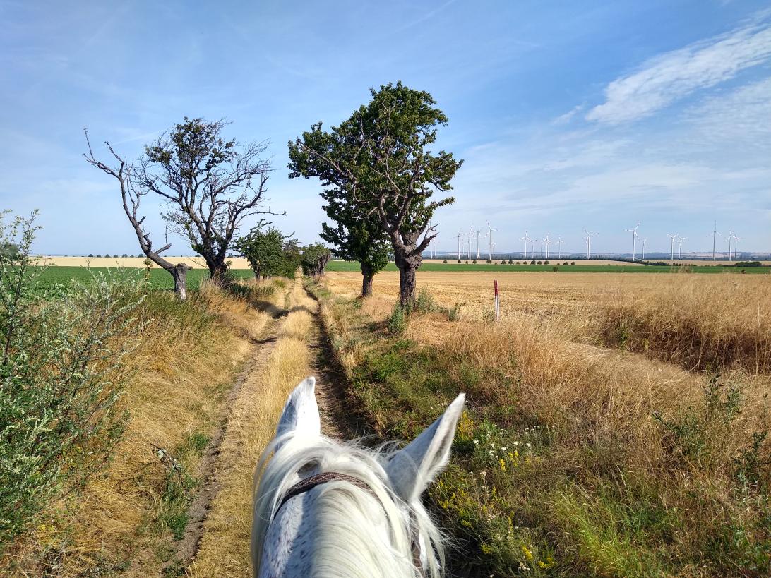
meadow paths, bypass three high wind turbines to the east. Good forest paths and a few
secluded forest meadows, before it goes on gravel (main road
of the forest) into an intermediate valley - Thuringian Muschwitz, federal state border and an
older sign “ Green Belt“, 9:05, 9 km. The signs have been placed on the
fixed paths everywhere, a continuous connection path (as the
"belt" suggests) does not exist or no longer exists. It's a
recent way; the historical maps show no transition here.
Next we come to the Rennsteig (famous historical road and
high altitude hiking trail), which we only cross today.
At the top we bypass Helmsgrün: Nice paths; on a
meadow after 15 km first break (9: 45-9: 55), and before
Remptendorf again from 11: 15-25 (26.2 km). Through the two
villages of Heinersdorf and Eliasbrunn: very beautiful
slate-roofed houses, probably more expensive than the small
farmers used to have. Then over a single-track railway line
at the former, completely dismantled station between two
villages, now no longer a real transition, and over the
adjoining former military training area: no signs,
apparently ammunition-free area - which is unfortunately not
the case everywhere - and further through the heather along
the High voltage lines.
I hurried because there is a small supermarket in
Remptendorf that closes at 12:30. There is a nice meadow
next door for Khorsheet, where we are going to lunch (11:
50-13: 00), especially since we have already ridden 28 km.
The horse gets freshly bought oatmeal and apples, I have a
measure of locally brewed, ice-cold beer, learn all stories
of horse farms in the area from curious villagers, and we
have good chat.
The way to Karolinenfield is a construction site,
then asphalt, then gravel, through the forest for a short
stretch. There an inn (probably a day of rest) and a lot of
cows, in total tons of gravel. Because its really sucks, and
not a centimeter of a verge has been left, we take way
across an eroded pasture: lifted one stake, led the horse
under it, and trampled the stake again. That's how it works
in Thuringia, no problem at all. Another reason for sturdy
footwear when riding.
Down to the Saale in Wahlsburg, then steeply
uphill, street. Past all kinds of "Datschen" from the GDR era, an
old villa is now a "cat's hotel" ... break in Essbach,
across from the large cooperative, 38 km, 14: 40-15: 00. Huge tractors come and go,
who would have time to bring water or feed to a horse?
After 45.7 km at the Plothenbach 16: 15-30, grass
again, the fifth break today. We are obviously dawdling now,
drawing on the lead we rode out in the morning, because I
don't want to ride any further than our stage location
planned for today, then I would have to go 7 km further, and
that throws everything upside down for the following days.
But there is also no point in arriving at 3:00 p.m., because
then nobody is there to ask for accommodation.
In the village I see a couple of small horses in
the pasture. When asked in a large four-sided courtyard, I
quickly hear who they belong to, and a recreational rider
offers a village meadow surrounded by a picket fence with
short, good grass for Khorsheet. She also has some muesli
for the horse, because after yesterday's bivouac, my stock
of feed is empty. Where there are so many fish ponds here, I
eat fish in a nearby restaurant, but not carp but pikeperch.
A little further away is a riding facility that seems to
belong to a farrier. But my horse is fine here and we don't
have to detour do. The
lady and her boyfriend come by with a bottle of wine, and we
cheer for the horses and a long life in the sunset. I don't want to make any
more trouble than necessary and spend the night with the
horse in the meadow.
I want to leave some money for meadow, horse
muesli and some fly remedy (small spray bottle), but the
lady firmly refuses to accept anything. So I just thank kindly.
At 7:35 am I leave.
We want to go north on the watershed between Saale
and Weißer Elster, the Autobahn 9 also cross over this
height. We
have ridden west of her since Betzenstein on the Franconian
Jura, and it should stay that way today, but we are closer.
Often in sight
but hardly within earshot.
Beautiful paths lead between the ponds, but they
end in an old windbreak. I lead through the branches, then a
couple of beautiful meadows (with many hunters seats) and
over a disused railway line with half-rotted wooden
sleepers. No real way through to the north. It gets better
with the L1077. Before Linda paddocks with many horses at
the windmill. Solid paths in the forest that are reasonably
easy to trot. On a large meadow with cattle paddocks, a nice
rest area with a “horse parking lot”: First break after 10.7
km from 9: 10-40.
At Traun I leave the forest
height. Beautiful view down to the Orlatal and the silver
ribbon of the A9 2 km away
The road down into the Orlatal, from Traun to
Kopitzsch I lead 3 km. Shortly before the village I met a baker's car,
which I stopped waving arms: two apple pieces for me and a
bread for Khorsheet.
I can trot up the next hill again. Good up to the forest, then
over a short stretch of the track is overgrown and difficult
to find. Then
good ways again.
On a slightly overgrown meadow at the Jägerdreieck
(20.2 km) second break from 11: 25-45. A while longer along the
forest height, then into the valley near Ottendorf, and
opposite 100 m of altitude, the Selig steep up (leaded). At the height of a long
Canter over beautiful stubble fields. Khorsheet is not strained
from the hills and hardly sweats. Nonetheless, a break on a
beautiful meadow just before heading back into the forest -
12: 45-13: 30 (27.8 km).
Passing under the A4 near between
Teufelstal-bridge and Hermsdorfer Kreuz. The "new" bridge is not
worth a detour to me. In 1997 I rode in this valley with Ligeira and
Natascha, saw the "historical" bridge from 1938, and stayed
in the neighboring village. The path now ridden instead
is certainly better and less noisy.
Schleifreisen is the next place: Incredibly steep
local streets made of very smooth, slippery cobblestones. The way into the valley
confuses me a bit, I look for it in the wrong direction and
wonder why there are houses. Every now and then you have
a real "card blackout". I guide you through the whole place up to the
Zeitzgrund. There
hard paths with lots of tunnels, probably from the
Janismühle horse company.
In a dense wooded area west of the A9, only the
gravel roads can be used. Much unprocessed windbreak
lies around. At
the "Drei Grauen Ziegenböcken" (three gray billy goats)
busy, dangerous (narrow) street, but all the roads around
are overgrown. The restaurant - historical street inn - has, as
can be read, closed and is apparently being renovated.
In the first place north of the Jenaer Woodland, I
finish according to plan for today. According to the map, the
place appears to be shaped by small farmers, and that's how
it is. In the
first courtyard I ask for accommodation, because I see
paddock panels on the nearby meadow. I am told that these are
for cows, not horses. The neighbor has two cows and a couple of sheep
and gives me his summer house with a meadow to sleep over. A nice, hospitable guy - dinner in the nearby village inn, good and cheap,
only 12 Euros including two small glasses of beer!
The garden shed even has electricity to charge the
power bank! Early
in the morning - I am freshly shaved and ready to go - the host comes by with fresh rolls. He still has a bit of
forest that he wants to go out into this morning to make
firewood. Khorsheet
is full and is given the rest of the muesli in the feed
sack. - Start
8:30
Old local connection route to Silberthal and
Droschka. Very
beautiful paths and great views of the Kesselberg (parking
lot / parking space with meadow) and through the field over
the Goldberg. We
trot.
Then very hard paths in the forest to the
Tautenburg observatory, where we probably turned a path too
early. Large gatherings of hunters are out and about with
SUVs and pickups. We turn onto a slightly overgrown path,
after 12.6 km ridden we take the first break of 10.20-35 at
the gate beech in the forest. The paths are better now, and
on a beautiful unpaved path (partly with hoof marks) you go
through sheep meadows down into the Saale valley to
Dorndorf.
In the small town I have to make a 600 m detour.
The old, narrow steel arch bridge ( Carl-Alexander-Brücke
from 1892 ), over
which I rode 22 years ago, and over which all traffic rolled
at that time, is closed for the purpose of reconditioning.
We have to wait to the new bridge and in front of the rails
and let a regional train pass. A steep path up out of the
village; I take a photo with Dornburg Castle in the
background in the same place as in 1997, and Khorsheetchen
even stands in the same position as my good, unforgettable
Ligeira then ago ..
Good paths in the field; second break on a grass
path in front of Hirschroda 20.3 km 11: 55-12: 20. Khorsheet
is no longer hungry.
In the damned next village,
a local road was unbelievably built up and fenced off, a
whole inner town block turned into a dead end, so I made a
600 m detour in the town on sloping, poor, smooth pavement.
The following path over the height and through the
wind turbine area is better to ride than I exspected. After
several days I have to go buying foodstuff again, make a
short detour to Bad Sulza and cross the train at the
entrance to Darnstedt. Well-maintained cycle path in the
valley all the way to the rural market in the valley
meadows. I let Khorsheet graze freely, she walks a few dozen
meters to the nearby Ilm while I'm in the market because she
is apparently thirsty. But, as I noticed when approaching,
there is no way down. A few children are amazed that she is
running around freely and take care of her. Third break from
13: 45-14: 25 30.5 km
The houses on the exit road looking empty so noone
to ask for water. Over the next height beautiful paths, trot
and canter to the next place. I am leading across the
clanking pavement when a stout craftsman comes out of a
courtyard. I kindly ask for water, and he asks back if my
mount is a purebred Arabian. He had some too, and even drove them in front of
the carriage. Now he has Haflingers for his daughter. They
are in the neighboring yard. I get water and also black oats
(which are quite fuzzy). Everything is now ready for today's
bivouac. I just want to ride another 4 km. A couple of older
people show me the way to the former LPG on the outskirts.
Then it goes to the vantage point Vier Linden, which is
beautifully located in the middle of dry sheep pastures
(fourth break 16: 05-25) where I let my horse eat again. The
grass here is too barren for an overnight stay. The "Battle
of Jena and Auerstedt" took place here, and ended
catastrophically for the Prussians. Napoleon simply had the
better trained officers.
The Holländermühle in Eckartsberga is only half of
an hour away and I reach it at 16:55 after 6:50 a calculated
riding time and 38.6 km. This is the end of the second quarter of my route
map, and we have made it half the route, exactly as planned.
The grass around the mill and the small seating
area is so dry that Khorsheet needs an extra 15 liters of
water, which I get from the empty neighboring house with the
watering can.
In 1997 I was here before, at that time I had to
bring my 4-year-old pack horse Natascha home from here
because she was lame at the rear. The mill's restorer,
blacksmith Peter Hähnert, explained the design and
construction to me at the time. I have learned that he has
not been among the living for several years. The steel wheel
of the mill has meanwhile been dismantled. It was lost but
has since appeared again, I hear.
Suddenly small jeeps and SUVs roll in from all
directions, and men and women dressed in green loden get out
of them. The hunting horn blowers from Hegering come
together and serenade the visitors of the mill: an elderly
man with a braid (who raves about old GDR times and cuts a
slice of the herb bread he has just bought), his
granddaughter and me. Khorsheet stands next to it, grazing
and watching the goings-on with pricked ears, apparently
casually.
“Isn't it shy when we start
blowing?” Ask the hunters - “If the right signals
come out, then it will stand at attention” is my answer, and that's how it is. We keep a nice chat; the hunters let liquor by
and I get the sherry out of the saddlebag.
When it is already dark, in the meantime I have
set up the paddock and safely stowed the horse, one of the
hunters comes back, who actually wanted to shoot a wild
boar, and asks if he can give me his 10 liter water bucket,
which he is probably has in his car for washing hands, for
the horse overnight. That is a real kind thought, and very welcome at
this dry altitude, and so I thank him warmly. When I set off, I put the
canister behind the bushes, as requested, and the "borrowed"
watering can behind the garden gate of the nearby house.
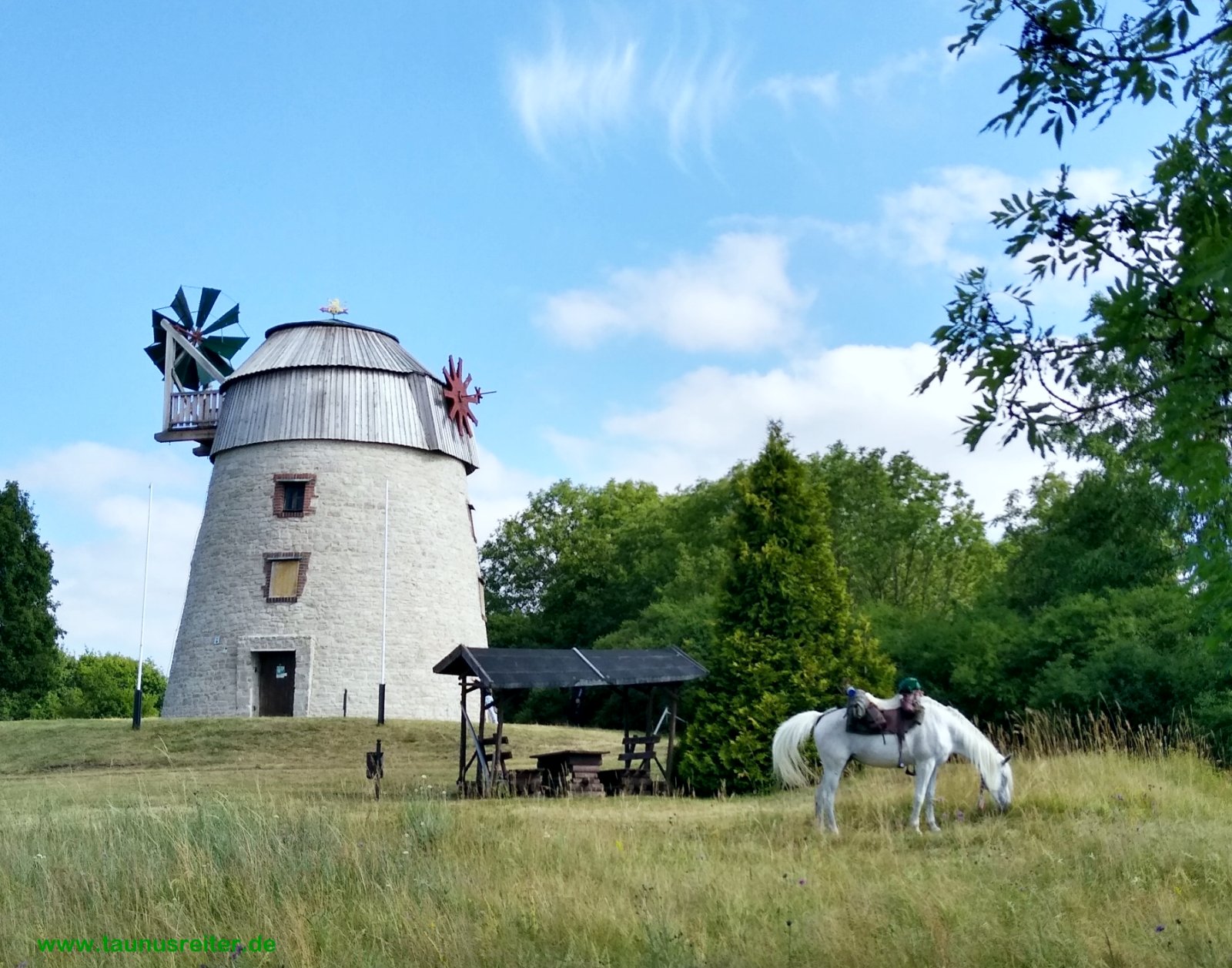
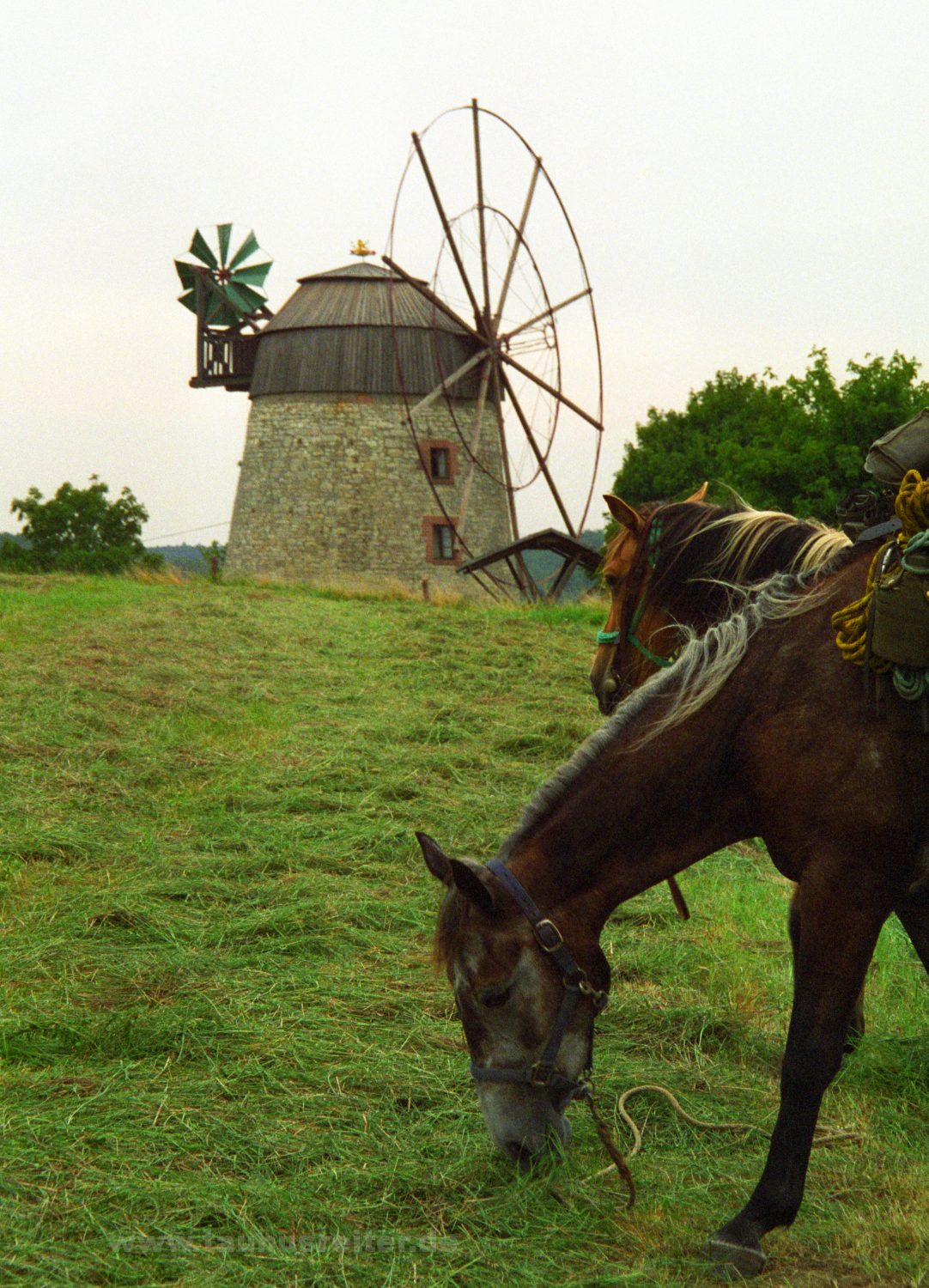
Photo of 1997, with Ligeira
and Natascha